


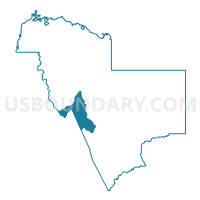
Roosevelt Voting District, Gila County, Arizona
About
Outline

Summary
| Unique Area Identifier | 523818 |
| Name | Roosevelt Voting District |
| County | Gila County |
| State | Arizona |
| Area (square miles) | 169.27 |
| Land Area (square miles) | 153.96 |
| Water Area (square miles) | 15.31 |
| % of Land Area | 90.96 |
| % of Water Area | 9.04 |
| Latitude of the Internal Point | 33.63374190 |
| Longtitude of the Internal Point | -111.06755620 |
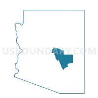
Maps

Graphs
Select a template below for downloading or customizing gragh for Roosevelt Voting District, Gila County, Arizona


Neighbors
Neighoring Voting District (by Name) Neighboring Voting District on the Map
- Globe #1 Voting District, Gila County, AZ
- Miami #1 Voting District, Gila County, AZ
- Sierra Ancha Voting District, Gila County, AZ
- Tonto Basin Voting District, Gila County, AZ
- TORTILLA FLAT Voting District, Maricopa County, AZ
Top 10 Neighboring County Subdivision (by Population) Neighboring County Subdivision on the Map
- Globe-Miami CCD, Gila County, AZ (18,134)
- Tonto National Forest CCD, Maricopa County, AZ (9,713)
- Tonto Basin CCD, Gila County, AZ (3,350)
Top 10 Neighboring Place (by Population) Neighboring Place on the Map
Top 10 Neighboring Elementary School District (by Population) Neighboring Elementary School District on the Map
Top 10 Neighboring Unified School District (by Population) Neighboring Unified School District on the Map
Top 10 Neighboring State Legislative District Lower Chamber (by Population) Neighboring State Legislative District Lower Chamber on the Map
Top 10 Neighboring State Legislative District Upper Chamber (by Population) Neighboring State Legislative District Upper Chamber on the Map
Top 10 Neighboring 111th Congressional District (by Population) Neighboring 111th Congressional District on the Map
Top 10 Neighboring Census Tract (by Population) Neighboring Census Tract on the Map
- Census Tract 10, Gila County, AZ (5,094)
- Census Tract 101.02, Maricopa County, AZ (4,640)
- Census Tract 7, Gila County, AZ (1,710)
- Census Tract 8, Gila County, AZ (1,281)